Sunday, June 9, 2024

2024 - Oregon and California Trip

Fei and I have been looking forward to visit the Crater Lake NP and Redwood NP since a couple of years ago, and we finally made a decision to visit both NPs in May, 2024.  Our original itinerary was as the following:


Sun, May 12, 2024 - Fly to Portland and drive to Astoria, Or

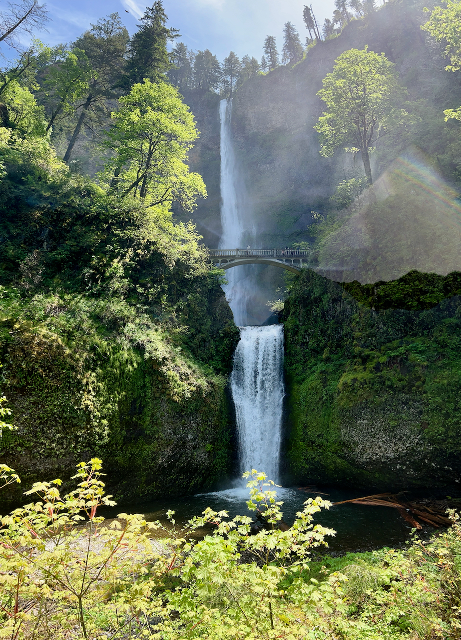
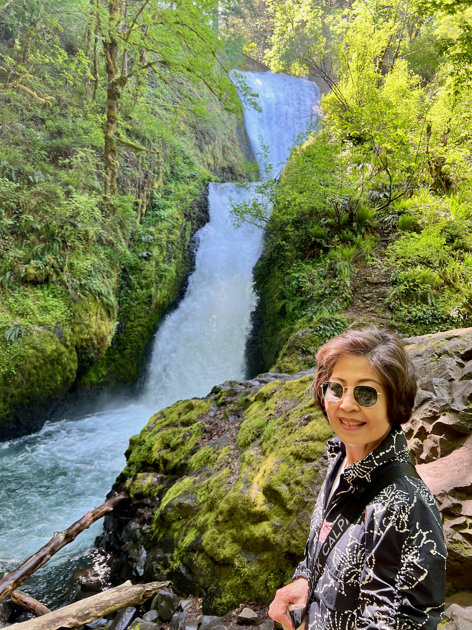
Mon May 13, 2024 - Visit Columbia River Gorge 

Tue May 14, 2024 - Visit Mt Hoot area

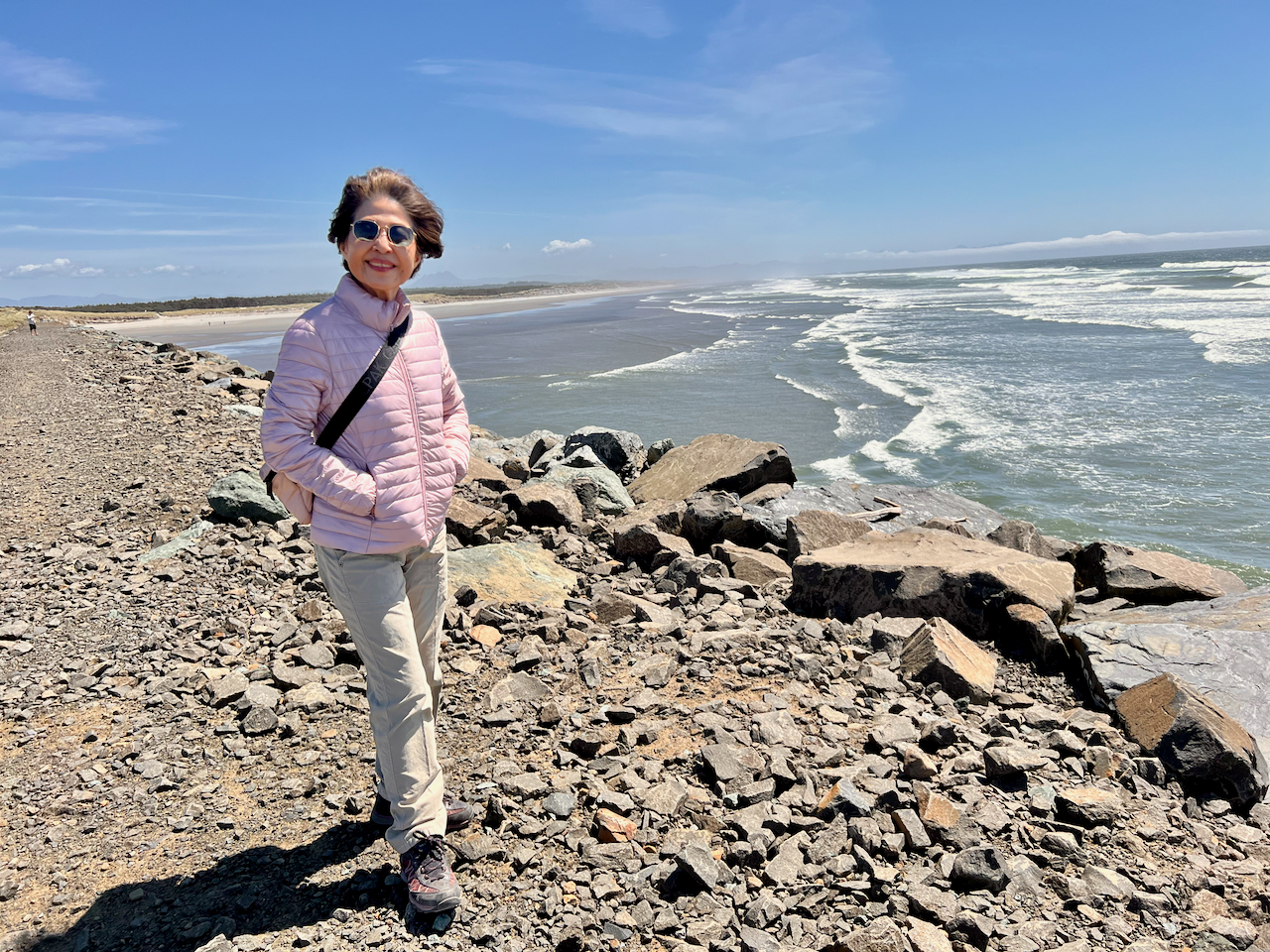
Wed, May 15, 2024 - Visit Oregon Coast (northern part)

Thu, May 16, 2024 - Drive to Medford, Or

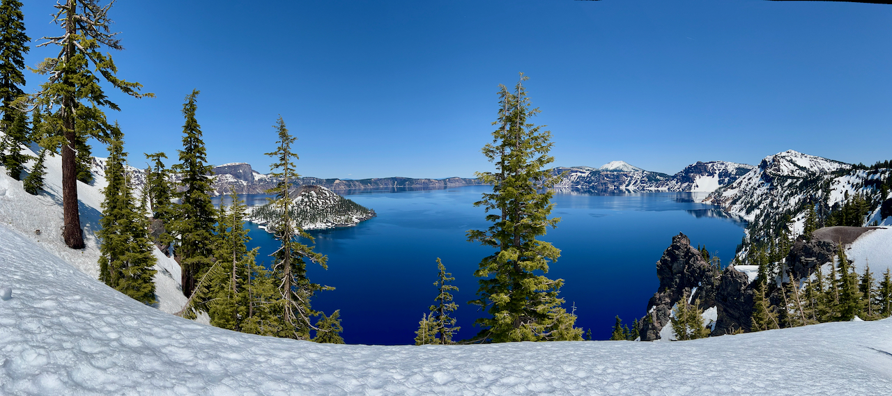
Fri, May 17, 2024 - Visit Crate Lake National Park

Sat,  May 18, 2024 - More visit to Crate Lake National Park and drive to Crescent City, Ca

Sun, May 19, 2024 - Visit Redwood National and State Parks

Mon, May 20, 2024 - Visit Redwood National and State Parks

Tue, May 21, 2024 - Drive to Portland and fly back to Houston


After we got to Oregon, we found out that Mt Hood is a ski resort area and there is not much we can do if we don't do skiing. Therefore, we just drove by State Highway 26 and viewed the Mt Hood area on the same day we visited Columbia River Gorge, and rearranged the schedule to visit other attractions near Astoria, Or.


When we got to Crater Lake NP, we realized that May is still too early to visit this NP due to everything is still covered under the snow.  Therefore, after the visit, we were able to continue to travel down South Highway 101 to enjoy more scenery views along it.


Some of the highlights of out visits are as the following:

Sunday, May 12, 2024 - Fly to Portland and drive to Astoria, Or

Due to recent reports on the safety issues in the Portland downtown area, we decided to skip the downtown area and drove to the northwest corner of Oregon - the beautiful Astoria.  It is a small town on the edge of the Columbia River and the Pacific Ocean. It is famous for being the final point of the Lewis and Clark Expedition, the setting of the movie 'The Goonies', and its Victorian-era homes built into the hillside overlooking the Columbia River.  It is the oldest American settlement west of the Rocky Mountains.

The drive from Portland airport to Astoria took us to Washington State and then back to Oregon State.  The US 30 generally follows the southern shore of the Columbia River and it was a beautiful and enjoyable drive.  


After we checked into the Lloyd Hotel Astoria Bayfront, it was about 3PM and we took the opportunity to do some sightseeing around this famous town.  The highest rated attraction is the nearby Astoria Column.  It is a 125-foot-tall Astoria Column serves as a monument to the history of the Pacific Northwest. In 1925, Ralph Budd, president of the Great Northern Railway, approached New York architect, Electus Litchfield, with the renewed interest. Together with artist Attilio Pusterla, they formulated a plan to erect a column decorated with a sgraffito-style painted histogram recounting the region’s history spanning from the discovery of the Columbia River to the arrival of the railroad.

Today, the Astoria Column attracts visitors from around the world. Visitors may climb the inside of the tower (164 steps) to the observation deck at the top, which provides a spectacular view of Astoria and the Columbia River. This column has been seen in movies such as, Kindergarten Cop, Free Willy, Teenage Mutant Ninja Turtles III, The Goonies, and Short Circuit. 
Then, we drove to The Lewis And Clark National And State Historical Park to see if we can do some hiking there.  Unfortunately, we got there past their closing time, and they closed their gate to prevent anyone to get in.  Therefore, we only took photos at their sign near the entrance and drove to the canoe landing area for more photos.

We went back to the hotel and found out that they have complimentary salmon chowder  after 5PM 
everyday. Of course we did not pass the opportunity to try some chowder and it was surprisedly good.
It was Mother’s day, we did not know the status of the nearby restaurant, therefore we just drove to the highly recommended restaurant in town, the 'Bridgewater Bistro' to try our luck.  Fortunately, they found a table for us.  We had their special Chicken Lasagna and Fish & Chips.  They were delicious.

Monday, May 13, 2024 - Visit Columbia River Gorge

We had a nice and hot breakfast in the hotel, then we drove back to Portland area to visit the famous Columbia River Gorge.  The Columbia River gorge is a spectacular river canyon, 80 miles long and up to 4,000 feet deep, that meanders past cliffs, spires, and ridges set against nearby peaks of the Pacific Northwest’s Cascade Mountain Range. It is famous for its dozens of awe-inspiring waterfalls spill from basalt cliffs, lining the Historic Columbia River Highway, like the famous Multnomah, Bridal Veil and Latourell falls.


Our itinerary calls for visiting Vista House, Latourell Falls, Bridal Veil Falls, Multnomak Falls, Bonnerville Lock and Dam, Bridge of the Gods, After we existed I-84 and turned to the Waterfall Corridor, we started our visit at Vista House.  The Vista House was built in 1917 on one of the most beautiful scenic points on the Historic Columbia River Highway. It was constructed to provide travelers a place to rest and refresh themselves as they made their way down the magnificent Columbia River Gorge. 


At Vista House, we had a chance to check with the staff about what and where the attractions and the info regarding each falls.  We also learned from them regarding what to do in the Mt Hood area.  

We visited Larourell Falls first, and were impressed with the size of the falls and the amount of water coming down from the falls.  
Then, we moved on to the Bridal Veil Falls,  There is a short walk (0,5mi) from the parking area to the waterfalls. It was a pleasant hike and we were amazed when we saw the falls. It is known for their picturesque beauty, with a height of approximately 120 feet and a picturesque pool at their base. The surrounding lush greenery and towering trees add to the allure, making it a must-visit destination for nature enthusiasts and adventure seekers alike.  Quickly we found out that photo just could not capture the amazing beauty of the falls, therefore we started to do videos to give it’s the justice.  
Then, we moved on to the Wahkeena Falls.  It is a falls that you can see from the parking area.  There is a short hike lead to the actual falls.  For some reason, we got on the wrong trail and found out that we were on the returning trip from Mulmomah Falls to Wahkeena Falls.  It was a 20 minutes hiking trail and was an easy/pleasant one.  On the way to Mulmomah Falls, we found an unnamed small but beautiful falls like some of the falls we saw during our previous Japan trips. 
When we hiked to the Mulmomah Falls parking area, we noticed they were charging $20 for parking. I guess we saved $20 accidentally. Plummeting 620 feet, in two different sections, Multnomah Falls is the most-visited natural recreation site in the Pacific Northwest with more than 2 million visitors each year. We did try to hike up the top of the falls, however, due to time constraint, we just went up to half way and saw the most part of the falls closely from different angles.  It was an impressive attraction.

Then, we stopped by the Horsetail falls and just viewed it and took photos from the roadside viewing area.

We drove to Bridge of The Gods and found a lot of traffic, then we realized it is a toll bridge ($3 for a very short ride).  We were intended to turn around and the attendant won’t allow us, therefore, we have to cross the bridge, and drove on the north bank of the Columbia River to White Salmon and take another toll bridge back to south side of the bridge to continue our drive. At the same time we missed the original planned stop at Bonnerville Lock and Dam.

Since we learned that Mt Hood area did not have any attraction stops for sightseeing, we decided to follow the recommendation by just drive around the State Highway 26 back to Portland to just to admire the majestic Mt Hood by viewing from a distance.  We did stopped by the roadside and took photos with Mt Hood as the backdrop.

With this additional detour, we were able to eliminate another 5 hours of driving to/from Mt Hood on the next day.

When we got back to Llyod hotel, it was 9:30pm already.  However, they still had plenty salmon chowder left, so we took some back to the room and enjoyed it.

Tuesday, May 14, 2024 - Visit Oregon Coast (northern part)

With the elimination of visiting the Mt Hood area today, we moved up our next day’s itinerary to visit the Oregon Coast.  Since we were going to come back to the hotel in the evening, we decided to drive to the southmost coastal attraction and then visited all attractions from south to north.  


The first stop we made was Neahkahnie Viewpoint on Highway 101.  The Neahkahnie Viewpoint, offered a fascinating display of Oregon's coastal magnificence. No hike is needed to reach this vantage point, which overlooks clean and fresh beaches and the rough/uneven cliffs. The crashing waves together with the chorus of seabirds, creating a sensory symphony that reflects the untamed beauty of the Pacific.  There are 3 pullout areas for stopping and enjoying the beautiful scenery.  

Then, we drove to Cannon Beach to visit the Haystack Rock and Ecola State Park.  After we arrived to Cannon Beach, we just following the crowd and road signs and found the public parking for visiting Haystack Rock.  Therefore, Haystack Rock was our next stop.

We did not have much expectation about Haystack Rock.  After we got close to Cannon Beach, we can see the majestic Haystack Rock in distance with a lot of tourists there.

Haystack Rock is one of Oregon’s most recognizable landmarks, home to colorful tide pools

and diverse birdlife. It has been featured in countless novels, television programs, and movies such as the Goonies and Kindergarten Cop. This basalt sea stack rises 235 feet from the edge of the shoreline. Since it was low tide, therefore we were able to walk right up to it and find colorful sea stars and other fascinating tidepool creatures in its intertidal area. It was about a 10 minutes walk on the beach to get close to it.  When we got there, we found reflection of the rock and we took the opportunity to take reflection photos with it as backdrop.  

One interesting incident happened to Tony when he tried to get close to the rock, the wave suddenly came up and looked like the water will cover the area.  As he tried to get out of the situation, he did get his shoes wet.  But it did not stop us to continue enjoying this majestic Haystack Rock.  


They say Puffins can be observed on Haystack Rock from early spring to mid-summer, offering the most accessible viewing of Tufted Puffins in the Northwest. They were a lot of birds on top of the rock, however, it was too far away to tell if they were puffins.  As far as we could tell via viewing them through our telephoto lens, they were just normal seabirds. 


There was a puffin statue on the beach entrance area and the carved plate did mention the info regarding to the viewing of puffins on top of Haystack Rock.

Then, we drove to Ecola State Park and enjoy the scenery there.
We drove to Fort Stevens State Park to visit Clatsop Spit which is an unusually large sand spit on the Pacific coast, at the mouth of the Columbia River. The Clatsop Spit was formed by sediment brought to the coast by the Columbia River after the last ice age ended and the ocean level rose approximately 8,500 years ago. The area that is bound by the Pacific to the west and the Columbia River to the northeast and generally it is referred as the meeting point of Columbia River and Pacific Ocean.  There is an observation tower for viewing, however, it was closed to tourist at that time.  We went up the the jetty to view the meeting point of Pacific Ocean and Columbia River, however the wind was too strong and we only stayed on the jetty for a few minutes and we had to get back to the car.  

Then, we drove to the the Columbia Beach and walked along the bird viewing area for a little while.

The next attraction was the Wreck of the Peter Iredale.  Peter Iredale was a four-masted steel barque that ran ashore October 25, 1906, and is still visible, making it a popular tourist attraction as one of the most accessible shipwrecks of the Graveyard of the Pacific.

We decided to stay in the hotel and enjoyed their complementary salmon chowder as our dinner.  After dinner, we ventured out to the Astoria River Walk which is just behind our hotel.  It is the west starting point of the walk, and we walked to the west most point and watched sunset there.

When we walked back to the back of the hotel, we noticed that there were few deers there and we just stayed there and watched them for a while.  Some of the deers came very close to us and did not even bothered by our present.
Then, we walked about a mile or so to the east and back.  It was an enjoyable walk after the tasteful salmon chowder.

Wednesday, May 15, 2024 - Louis and Clark National Historical Park

We started our sightseeing with the Louis and Clark National Historical Park which was closed when we got there on day 1.  


President Thomas Jefferson had for years been fascinated by the vast and virtually unknown territory west of the Mississippi River, and in June 1803 he announced plans to send an exploratory party overland to the Pacific. He had chosen Lewis to head it, and Lewis selected Clark, his friend and former commanding officer to share the responsibilities. They were to explore the Missouri River to its source, then to establish the most direct water route to the Pacific, making scientific and geographic observations along the way. They were also to learn what they could about the Native American tribes they encountered and impress them with the technology and authority of the United States. The explorers started up the Missouri River from near St. Louis on May 14, 1804. After a tedious journey of five months, they wintered at Fort Mandan. In April 1805 the Corps of Discovery left Fort Mandan and followed the Missouri and its upper branches into an unknown world. Along the Lemhi River, in what is now Idaho, Sacagawea's people provided horses and a guide for the grueling trip over the Continental Divide. In November 1805, after some 600 miles of water travel down the Clearwater, Snake, and Columbia rivers, they finally sighted the Pacific. Within 10 days of arriving on the coast, Lewis and Clark decided to leave their storm-bound camp on the north shore and cross the river, where elk were reported to be plentiful. Lewis, with a small party, scouted ahead and found a "most eligible" site for winter quarters. On December 10, 1805, the men began to build a fort about two miles up the Netul River (now Lewis and Clark River). By Christmas Day they were under shelter. They named the fort for the friendly local native american tribe, the Clatsop. It would be their home for the next three months.


In the park, there is Fort Clatsop which was the encampment of the Lewis and Clark Expedition during the winter of 1805–1806. The original Fort Clatsop decayed in the wet climate of the region but was reconstructed for the sesquicentennial in 1955 from sketches in the journals of William Clark. The replica lasted for fifty years, but was severely damaged by fire in early October 2005, weeks before Fort Clatsop's bicentennial. A new replica, more rustic and rough-hewn, was built by about 700 volunteers in 2006; it opened with a dedication ceremony that took place on December 9.

Then, we hiked on the beautiful Netul River Trail (1 mile trail) to learn about the history of logging and commerce along the Lewis and Clark River. It was an easy and pleasant hike.
After that we drove to the nearby Young River Falls to see the beautiful waterfalls close to Astoria.  When we got there, there was nobody else and we had the whole falls by ourselves.  It was a peaceful and relaxing moment for us to enjoy.  In addition, there is a beautiful but strange tree next to it and we stayed there for quite a while to take photos. 
Then, we drove on the Astoria-Megler Bridge to visit the Fort Columbia Historical State Park in Washington State.  Astoria-Megler Bridge was built to withstand Pacific storms with wind speeds that reach some 150 miles (240 km) per hour and river currents that can hit speeds of 9 miles (14 km) per hour. The Astoria Bridge was meant to replace ferry service that was inefficient and subject to disruptions during bad weather. The bridge stretches 4.1 miles from Astoria, Oregon, across the mouth of the Columbia River to Point Ellice, Washington, and contains the longest continuous three-span through-truss in the world.

Fort Columbia State Park is considered one of the most intact historic coastal defense sites in the U.S. In addition to its historical significance, the area offers bird watching, miles of forested hiking trails and secluded beaches. The park grounds feature three artillery batteries and two coastal artillery guns. 

The wind was too strong for us there, therefore, we just wandered a little bit around artillery guns and then drove back to the hotel.